- Plan V.
- Posts
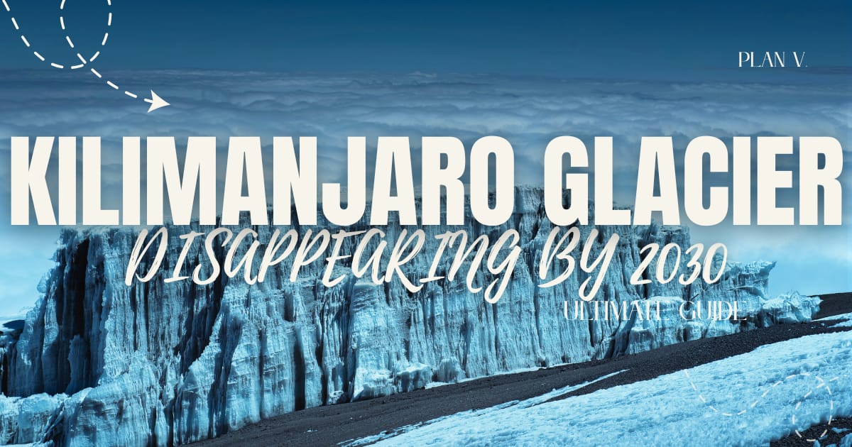
- 🧊🏔️Your Kilimanjaro Glaciers Are Disappearing By 2030—Here's Everything You Need To Know Before They're Gone 🧗🏻🇹🇿
🧊🏔️Your Kilimanjaro Glaciers Are Disappearing By 2030—Here's Everything You Need To Know Before They're Gone 🧗🏻🇹🇿
This isn't just a mountain climb. It's a journey through five distinct climate zones, from tropical rainforest to Arctic tundra, all in less than a week.
Plan V
November 14, 2025
In partnership with
Master ChatGPT for Work Success

ChatGPT is revolutionizing how we work, but most people barely scratch the surface. Subscribe to Mindstream for free and unlock 5 essential resources including templates, workflows, and expert strategies for 2025. Whether you're writing emails, analyzing data, or streamlining tasks, this bundle shows you exactly how to save hours every week.
Let's start with what you should know about Kilimanjaro.
Kilimanjaro isn't part of a range—it's a standalone volcanic massif that rises nearly 16,000 feet from the surrounding plains. It's the world's tallest free-standing mountain, a UNESCO World Heritage Site since 1987, and one of the Seven Natural Wonders of Africa.
BUT, incredibly, climbing to the top of Kilimanjaro does not require technical climbing skills. No ropes, no ice axes, no mountaineering experience necessary. Just determination, proper preparation, and respect for the altitude.
If you've been thinking about Kilimanjaro, the time is now. The mountain is melting. Scientists predict the glaciers that crown Kilimanjaro—those iconic white caps that have defined the "Shining Mountain" for millennia—could vanish by 2030 to 2060.

Understanding the Challenge 🧗🏻
Kilimanjaro isn't technically difficult, but it's genuinely challenging. You're not rock climbing or navigating crevasses. You're walking. But you're walking at an extreme altitude where oxygen levels drop to roughly 49% of what you breathe at sea level. About 90% of climbers experience some form of altitude sickness—headaches, nausea, fatigue.
The key is choosing a route with proper acclimatization time and ascending slowly ("pole pole" in Swahili—slowly, slowly).
🏔️ Numbers you need
| 🌤️ When to go?
|
The key: Choose January-March or June-October for the best conditions. If you want fewer crowds, consider October, late December, or early January.

Most coverage tells you what happened. Fintech Takes is the free newsletter that tells you why it matters. Each week, I break down the trends, deals, and regulatory shifts shaping the industry — minus the spin. Clear analysis, smart context, and a little humor so you actually enjoy reading it.
The Non-Negotiable 🧗🏻
Let's be clear: you cannot climb Kilimanjaro solo. It's illegal. Tanzanian law, enforced by TANAPA (Tanzania National Parks Authority), requires all climbers to be accompanied by licensed guides through certified tour operators.
Finding Your Guide: What to Look For ⛺️
Tanzania Tourist Board (TTB) License: Every legitimate operator must have this certification.
KPAP Partnership: The Kilimanjaro Porters Assistance Project ensures ethical treatment of porters. Look for operators displaying KPAP certification.
Wilderness First Responder (WFR) Certified Guides: Your lead guide should hold this internationally recognized emergency medical qualification.
TANAPA Registration: All guides must be officially registered with TANAPA.
Why Local Guides Matter 🏔️
Tanzanian guides—often Chagga people who grew up on the mountain's slopes—know Kilimanjaro intimately.
They summit multiple times per month, understand the weather patterns, and can spot altitude sickness symptoms before they become dangerous.
They'll monitor your vitals twice daily, guide your pace ("pole pole"), and make critical decisions about whether you continue or descend.

Guardians of the Mountain: Chaga People 🏔️
Understanding Kilimanjaro means understanding the Chagga (or WaChagga), the indigenous people who've lived on the mountain's southern and eastern slopes since the 15th-16th centuries.
Kilimanjaro is a place where there are portals to the afterlife, at least that's what the Chagga people believe.
Following tradition, the deceased were buried facing the summit of Kibo, which is considered the "House of God."
And it is there, according to legend, that there are two gates where heaven and earth meet. The gates divide into two paths, one leading to paradise and the other to the realm of ghosts. Both are located somewhere on the mountain.
Guides often offer tours to the communities that live on Kilimanjaro; if you have the opportunity to visit them, do so.
SPANISH SECTION:
Top 3 de Glamping en Oaxaca (Costa)
Aunque la idea nació en el Imperio Otomano, no fue hasta 2005 que Oxford agregó la palabra a su diccionario. Ahí se define como: “una forma de acampar que implica alojamiento e instalaciones más lujosas que las asociadas con el camping tradicional”.
El glamping es un alojamiento ecoturístico que siempre se preocupa por el cuidado del medio ambiente. En su mayoría son sustentables.
Reservar un glamping en Oaxaca es sinónimo de descansar en un ambiente rodeado de naturaleza, olas cambiantes y comida regional exquisita.
Choosing Your Route: A Real Comparison 🗺️
You have the option to choose one of the available routes, each offering completely different experiences; here's what you should know:
Lemosho Route (7-8 days) — The Best Overall
Distance: 42 miles.
Difficulty: Moderate-Challenging.
Success Rate: 90-95%.
Best For: First-timers and those prioritizing summit success.
Machame Route (6-7 days) — "The Whiskey Route"
Distance: 37 miles.
Difficulty: Challenging.
Success Rate: 70-85%.
Best For: Adventurous hikers with some experience.
Marangu Route (5-6 days) — "The Coca-Cola Route"
Distance: 40 miles.
Difficulty: Moderate (terrain-wise).
Success Rate: 42-65% (lowest of major routes).
Best For: Those wanting hut accommodation.
Northern Circuit (8-9 days) — The Hidden Gem
Distance: 56 miles.
Difficulty: Moderate (low daily gains).
Success Rate: 90%+.
Best For: Those with time and budget.
Rongai Route (6-7 days) — The Northern Approach
Distance: 44 miles.
Difficulty: Moderate.
Success Rate: 70-80%.
Best For: Rainy season climbs and those seeking solitude.
Umbwe Route (6 days) — The Challenge
Distance: 32 miles.
Difficulty: Very Challenging.
Success Rate: Low.
Best For: Experienced trekkers only.
The Five Climate Zones 🌤️
As you ascend, you'll trek through distinct ecological zones—it's like traveling from the equator to Antarctica in days.
The first ones 🧗🏻
| The highest 🏔️
|

Pack Your Suitcase🎒
🥾 What to Pack
| 🧊What to Avoid
|
SOME EXTRA TIPS:
Train well before you go, don't underestimate the altitude, don't try to save money by choosing the cheapest route because it won't work, don't minimize altitude sickness symptoms, don't ascend too quickly, and most importantly, listen to your guide.
See you next time,
The best HR advice comes from those in the trenches. That’s what this is: real-world HR insights delivered in a newsletter from Hebba Youssef, a Chief People Officer who’s been there. Practical, real strategies with a dash of humor. Because HR shouldn’t be thankless—and you shouldn’t be alone in it.
Reply